|
|
SEER*CMapper Choropleth Mapping with Estimate Reliability Information |
||||||||
|
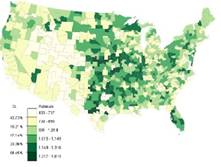
Objectives: A choropleth map is a popular map type to display
health statistics. Areal units are assigned to different classes according to
the statistical estimates of the units and each class is assigned a color (or
a pattern or symbol) on the map. Many methods have been introduced to
determine class break values to form classes, and some (e.g., natural breaks,
quantile, and equal interval) are popular in GIS, but none considers the
errors associated with the estimates in determining class break values. The Class Separability concept introduced in 2015
(Sun et al. 2015) can be used to assess the likelihood that estimates on two
sides of a class break value are statistically different – i.e., the level of
separability. Using this concept, the class separability classification
method was introduced to help determine class break values with high levels
of separability. The SEER*CMapper is a Java-based
stand-alone tool that can be downloaded to and used in local computers. SEER*CMapper can: 1) be
used to create state and county level choropleth maps using data from SEER*Stat; 2) create
choropleth maps using the class separability method and other popular
classification methods (natural breaks, equal interval
and quantile); and 3) evaluate
the separability levels of any map classification results. SEER*CMapper v.3 requires
Java installed or enabled (JRE or JVM). Version 4 is the latest release in
Fall, 2020, and it does not require users to install Java. Data: Two variables are needed: estimates and the
associated standard error (SE) or the margin of error (MOE). The MOE can be
at 90% or 95%. These variables are included in the SEER*Stat data exported in
text format. Boundary data of areal units are not required when using the
SEER*Stat data as SEER*CMapper includes the state
and county boundary data of the U.S. SEER*CMapper
can also handle shapefile data, as long as the attribute table includes the
estimate and the associated SE or MOE variables as attributes. Developers and
Funding Sources SEER*CMapper was developed
by David W. S. Wong and Yunfeng Jiang of
Spatiotemporal Information Systems, LLC. The concept of class separability
was developed in a project funded by the National Institutes of Health (NIH)
under Award Number R01HD076020 through George Mason University. The
development of SEER*CMapper was partially funded by
the NCI/NIH contract # NNSN261201700718P. The content in this website is
solely the responsibility of the author and does not necessarily represent
the official views of the NCI/NIH. |